daughter mother Sydney tour – Bridget + Wendy 11.09.26
 Troll Tours Pty Ltd
Bridget organised the daughter mother Sydney tour on a trike, for her Mum’s birthday. Our trike rider picked them up from their hotel in the Rocks, and took them on a fun 3 hour experience.
The Rocks
This is such an interesting place in/of Sydney, full of history. It’s the most historic place in Australia! It is a neighbourhood of historic laneways in the shadow of Sydney Harbour Bridge. The Rocks became established shortly after the colony’s formation in 1788 so it is the oldest residential, developed area in Australia – the birthplace of modern Sydney. With the arrival of European settlers in 1788, it was here that the convicts first set up house and shop.
Sydney Harbour Bridge
Firstly, they rode over the Sydney Harbour Bridge. We always tell our passengers to look up and enjoy the unique view. The more than 6,000,000 rivets are so interesting and the arch is so iconic. It’s nicknamed ‘The Coathanger’ because of its arch-based design. It is the largest steel arch bridge in the world. This bridge is the eighth longest spanning-arch bridge in the world and the tallest steel arch bridge, measuring 134 m (440 ft) from top to water level. It was also the world’s widest long-span bridge, at 48.8 m (160 ft) wide, until a bridge in Canada was completed in 2012.
Kirribilli
To the east, the rider took them through the back streets and into Kirribilli, to the Prime Minister‘s residence and Admiralty House. Kirribilli House is the secondary official residence of the Prime Minister of Australia.
Next door is Admiralty House. It is the Sydney residence of the Governor-General and one of the most historic and important residences on Sydney Harbour. The house – originally called ‘Wotonga’ – was built in the mid 1800’s.
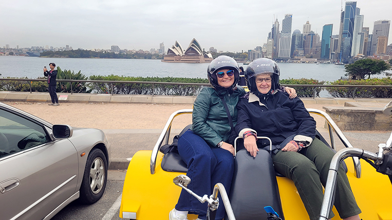
After that, they rode around the corner to Jeffrey Street Wharf. From here, the views across Sydney Harbour towards the Sydney Opera House and the CBD are magnificent. In addition, it also has an up-close view of the side and underneath of the bridge. What a great view of the Sydney Opera House and Harbour Bridge! It’s where this photo was taken.
The Kirribilli Loop – Harbour Bridge north side
From there, they rode under the north side of the bridge and continued on their tour. The underside of the northern end of the SHB – Sydney Harbour Bridge – is very interesting. The Kirribilli Loop was finished by riding past Luna Park and the North Sydney Olympic Pool.
McMahons Point / Blues Point Reserve
Secondly, they rode on through Milsons Point, did a left hand turn and rode up a few streets. This leads to Blues Point Reserve. The views over Blues Bay towards the Sydney Opera House, the Harbour Bridge and the CBD are just stunning. Already, the daughter mother Sydney tour on a trike was showing the main icons of the Emerald City.
Then it was back over the Sydney Harbour Bridge.
St Mary’s Cathedral
They rode through parts of the city and past St Mary’s Cathedral which is very impressive, even when riding past. It’s a Gothic Revival architectural building which opened in 1928. It took from 1866 to 1928 to build and has a height of 75m.
Art Gallery of NSW
Further on they turned left, along Mrs Macquaries Road. The Art Gallery of NSW has beautiful historic sandstone buildings which were built between 1896 and 1909. The Art Gallery of New South Wales began without a collection and without a building on 24 April 1871 when a group of 30 art-loving citizens established a society to support artists and promote knowledge and enjoyment of art in the wider community. In 1874 they secured government support for their project and by 1880 they had their own dedicated building, the first of its kind in Australia.
Domain
Also, this road goes through the Domain. The Domain is a heritage-listed 34-hectare (84-acre) area of open space located on the eastern fringe of the Sydney CBD. As usual, the daughter mother Sydney tour on a trike was showing some beautiful sights and icons of Sydney.
Mrs Macquaries Chair / Point
This leads to Mrs Macquarie’s Point. This peninsula was named in 1810 after Elizabeth, Governor Macquarie’s wife, who ordered a seat to be chiselled into the rock from which she could view the harbour. Mrs Macquaries Chair, as it’s known, is still there today. It’s in the Domain but is effectively an extension of the Botanic Gardens.
Woolloomooloo, Harry’s and Garden Island
Further on, Woolloomooloo is known for Finger Wharf, an old cargo dock that attracts a trendy clientele with fine dining, hip bars and water views on all sides. It also has the famous Harry Cafe De Wheels which has been serving customers for over 80 years. They make delicious pies, hotdogs and more. Lots of interesting photos are on the walls, mostly of famous celebrities who have visited over the years. They rode past Garden Island which is the location of a major Royal Australian Navy base. Then it was up the hill and into Potts Point.
Kings Cross
Continuing on, they rode through the infamous Kings Cross, though it has calmed down a lot since it’s heyday – home of the famous and huge Coca Cola sign. Kings Cross is also home to nightclubs and ladies of the night though it is not nearly as raunchy as it was in the 1970s (apparently).
Coca-Cola billboard
Look up to see the famous “Coke Sign”. It is an advertising billboard erected in 1974 by the Coca-Cola Company. More often regarded as an iconic landmark than as an advertisement. The new Coca-Cola sign was officially turned on, on 15 September 2016, and uses a lot less power. It is the single largest controllable LED sign in the Southern Hemisphere and can change colour.
Rushcutters Bay
Next is Rushcutters Bay. After British settlement, the area was first known as ‘Rush Cutting Bay’ because the swampy land was covered in tall rushes used by early settlers for thatching houses. In 1878, 2 hectares (6 acres) were reserved for recreation; and, after reclamation work was completed, Rushcutters Bay Park was created. The daughter mother Sydney tour on a trike is fun and interesting as well!
Rose Bay
Further east, they rode through Rose Bay. It is a harbourside eastern suburb of Sydney, located seven km east of the CBD.
The name Rose Bay was used as early as 1788 by Captain John Hunter. HMAS Tingira, named after an Aboriginal word for ‘open sea’ was moored in Rose Bay from 1912 to 1927. It was used to train over 3,000 Australian sailors, many for service in World War I. There is a small park on the Rose Bay waterfront which commemorates Tingira.
Double Bay
The suburb of Double Bay is a harbourside eastern suburb 4 km east of Sydney CBD.
It takes its name from the bay of Sydney Harbour and refers to the two geographical formations between Point Piper and Darling Point, which are interrupted by a miniature point in between. It has some of the most expensive real-estate in Australia and is colloquially often referred to as “Double Pay”, a term coined due to the high income of people living there, and the nature of the shopping area which features high-end fashion labels.
Vaucluse
Up the hill, they headed north through the posh eastern suburb of Vaucluse. The first European activity in the area took place not long after settlement, when a makeshift signalling station was set up on the ridge overlooking the ocean. Its role was to signal the colony if a ship was approaching. Pilots based at Camp Cove, Watsons Bay, could then meet the ship and guide it through the harbour. A formal signal station was established in 1790, serviced by a bridle trail that later became Old South Head Road in 1811.
Macquarie Lightstation
Then, they headed north and stopped at Macquarie Lightstation / lighthouse for a photo (or four). Completed in 1818, Macquarie Lighthouse was designed by convict architect Francis Greenway for Lachlan Macquarie, the Governor of NSW. Owing to crumbling foundations, it was reconstructed in the 1880s. Standing at 26 metres tall, the replacement tower was designed by the state’s Colonial Architect, James Barnet, to closely resemble Greenway’s original.
Watsons Bay
Even further north to Watsons Bay. It sits on the end of the South Head peninsula and takes its name from the sheltered bay and anchorage on its western side, in Port Jackson (Sydney Harbour). Fabulous views across the harbour to the Sydney Harbour Bridge.
The daughter mother Sydney tour on a trike, now in eastern Sydney has shown a fun perspective to our beautiful city.
The Gap
Opposite is “The Gap” . The view is towards North Head and out to the South Pacific Ocean. The Gap is an ocean cliff which faces the Tasman Sea, and is located in the suburb of Watsons Bay. Although the cliff is a popular tourist destination, it is infamous for suicides.
Gap Park is located on a coastal escarpment on Sydney Harbour’s South Head. It has spectacular views of both the harbour and the ocean. A weather worn memorial to an officer killed in the Boer War, is at the entrance to Gap Park.
Bondi Beach
Next, they rode south to the world famous Bondi Beach. This is the beach where Bondi Lifeguards of the Bondi Rescue TV series is filmed. When in Sydney it is one of the places you should visit. The beach is seriously nice (but not our favourite) but it’s good to say you have seen it. Bondi Beach is one of the most visited tourist sites in Australia. Bondi Beach is recorded by the Australian Museum that Bondi means place where a fight using boondi sticks (nullas nullas or fighting sticks) took place.
They stopped near the Lifeguard Tower to have a look and take photos.
Tamarama
Riding along more beautiful, though possibly less well known, beaches. The suburb of Tamarama has a small ocean beach about 1 km south of Bondi Beach and a couple of hundred metres north of Bronte Beach. It is an extremely narrow beach and deceptive for its size. Tamarama Beach is often referred to as Glamarama (or Glamourama), owing to the alleged abundance of glamorous people who sunbathe (often topless), on what must be one of the smallest strips of sand in the state (Wikipedia).
Bronte Beach
Then to the southern end of Bronte Beach which sits on Nelson Bay, surrounded by Bronte Park. Bronte offers scenic cliff-top walking paths south to Coogee via the Waverley Cemetery and north to Tamarama and Bondi Beach.
Bronte-Coogee Aquatic Reserve
Next, it was to the Bronte-Coogee Aquatic Reserve. This extends from the southern end of Bronte Beach to the rock baths at Coogee Beach and out to 100 m offshore. It covers an area of approximately 40 hectares and includes 4,000m of coastline.
The objectives of the aquatic reserve is:
1. conserve the biodiversity of fish and marine vegetation
2. protect fish habitat
3. facilitate educational activities
4. facilitate scientific research.
Clovelly Beach
Then it was to Clovelly Beach. Clovelly Beach is a small and tranquil beach, located the mouth of a narrow bay between two rocky ridges. The daughter mother Sydney tour on a trike has shown areas that most visitors to Sydney don’t see,
Coogee
Further on, they rode to both the south and north end of Coogee Beach. At the southern end is Wylies baths (open 365 days a year), as well as McIver’s Baths, which is the only remaining female-only ocean pool in Australia (dating back to 1886).
😆 The name Coogee is derived from the Aboriginal word ‘koojah’ which means ‘bad smell’ or a ‘stinking place’.
Maroubra
Riding south, Maroubra is one of Australia’s top surfing beaches, Maroubra is best enjoyed outdoors. An official National Surfing Reserve, the spectacular 1km-long beach is wrapped by a rocky headland and natural bushland.
The next beachside suburb they rode through was Maroubra. It is a local Aboriginal word meaning place of thunder. In 2006, Maroubra Beach became the second Australian beach to be named a National Surfing Reserve. Maroubra Beach stretches for approximately 1 km on Maroubra Bay.
Little Bay
The little known Little Bay area was first used as a sanitation camp during Sydney’s smallpox outbreak in 1881–82, to isolate the healthy contacts of sufferers of the disease. Also, bubonic plague in Sydney of 1900 and then again when soldiers returning from Europe brought the influenza virus back in 1919. Little Bay was an ideal location because it was isolated from settlements but still close enough to Sydney.
La Perouse
This beautiful peninsula in Sydney’s southeast is where Captain Arthur Phillip’s First Fleet initially landed in 1788, before deciding to settle at Sydney Cove. La Perouse is named after a French explorer who arrived in Botany Bay a week after the First Fleet. Nearby is the 1880s-built Bare Island Fort, which you might recognise from the Tom Cruise film Mission Impossible 2.
By now, the 3 hours was almost up. The rider turned around and headed north-west through the city and back to their hotel.
In conclusion, the daughter mother Sydney tour, was a great and unique experience. Something different to do in Sydney and very memorable.
Feel the Freedom!
Check out our Tours & Prices page. Don’t forget every tour is unique so may not be exactly as stated but you will always see the icons mentioned.
or just email trevor@trolltours.com.au and tell us what you would like to do.



 Troll Tours Pty Ltd